

Melchiorgarden
Start

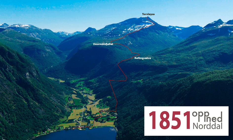
Rellingsetra
570 m.a.s.l.

Daurmålsfjellet
805 m.a.s.l.

Torvløysa
1851 m.a.s.l.
The Old Trail
(Please note: this trail to Torvløysa is no longer in use)
The races start and finish in Melchiorgarden. The first kilometer across the river, past Petrines Gjestegiveri and up to the kindergarten, is paved and relatively flat.
Here you will take to the left through a gate, which follows an old road in quite a heavy ascent up towards Rellingsetra. After 2.8 km with an altitude of 300 meters, one will cross the road and continue on the path towards Rellingsætra (570 meters above sea level and 4.2 km). From here the path gets a little less challenging, going alongside a river called Dyrdøla towards Dyrdalen. After 5.3 km, one will cross the river (which runs from Storvatnet) by a bridge and continue on the path which leads you to Innsetsetra (altitude of 600 metres above sea level). When reaching Dyrdøla, one is advised to fill up with water, this is the last chance to get water before reaching the top. From Innsetsetra, one will follow the trail in a pretty heavy ascent towards Daurmålsfjellet. When it starts to flatten out a bit one will reach a swamp and a sign that points towards Torvløysa. From here, the participants going to Daurmålsfjellet will run straight ahead to the turning point at the tip of the mountain, with a beautiful view over the village of Norddal.
The participants going to Torvløysa turns east upon a ridge that runs parallel with Dyrdalen. At this point there’s about 1000 meters of altitude and 5.5 km left to the top that lies in the south. The first part along the ridge is relatively easy to follow, but it becomes increasingly steeper and more challenging to get a good foothold. The track is marked well, with red stone cairns, and small red flags.
After 10 km and a 1450 altitude, one will reach a plateau of 500 meters which appears flat and has a great view (in nice weather) towards Storvatnet, Storvasshornet, and Skårene in the west and south-west. The terrain towards the top consists of a lot of raw gray stone, which can be quite heavy, steep, and rough to go through before the trail flattens out the last 300 meters. Length 12.2 km, 1851 meters above sea level.
The terrain surrounding the stone cairn at the highest peak is open and quite flat, the substrate is a mixture of small and large slabs of stone. Here one will have a 360-degree panoramic view towards Pyttegga in the east, Kupenibba in the south, Skårene in the west, and Norddal and the Norddalsfjord in the north.
The descent will be a great experience on the way back down to the finish line. If the weather is nice, one will get to enjoy a breathtaking view whilst navigating one’s feet along the ridge back towards Daurmålsfjellet. When passing Innsetsetra and Rellingsetra, one’s feet might begin to feel tired, but there’s still a bit left.
When crossing the finish line, you’re back where you started.